Saturday, September 8, 2012

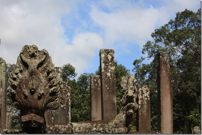
Bayon temple, Angkor Thom, Cambodia.

16th August, 2012 (our 37th wedding anniversary).


This was such a huge day that I’m struggling to remember the sequence of events.  We definitely walked over the Naga Bridge and through the South Gate.  Then I think we boarded our two minibuses, which must have appeared from somewhere, and drove a bit over a kilometre to the Bayon Temple, right at the centre of Angkor Thom.

IMG_3217 - Copy
When we hopped out of our buses near the Bayon Temple, the first thing to catch the eye was an elephant.  I get very excited about elephants, and Meredith, the youngest member of our group, would dearly have loved to have a ride, but our guide urged us along, saying that unfortunately, our schedule was too tight to allow for elephant rides.
Little did we realise just how much more he had in store for us that day.

IMG_3226
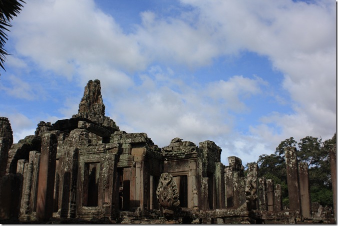
Here is the Bayon waiting for us between the trees.

IMG_3238 - Copy
The Bayon's most distinctive feature is the multitude of serene and massive stone faces on the many towers which jut out from the upper terrace and cluster around its central peak.
How many stone faces can you see here?  Altogether, there are 216 gigantic faces on the temple's towers.

Stone faces up close:
IMG_3255

IMG_3253
Like the faces on the devas and asuras on the Naga Bridge leading to the South Gate, these faces might represent:
  • King Jayavarman VII himself
  • the bodhisattva Avalokiteshvara
  • guardians of the empire's cardinal points
  • some combination of these
The central tower rises 43 metres above the ground.  Here are more shots of the Bayon, in an attempt to show the vastness of this structure:
IMG_3232

IMG_3234

IMG_3237 - Copy
Some temple lions …..
IMG_3235
….. and of course some nagas.
IMG_3244

IMG_3249


IMG_3260
Here I am, looking out a window.  At least it was shady and several degrees cooler in here.
IMG_3261
We didn’t exactly have the Bayon to ourselves.

Apsaras are beautiful, supernatural female beings. They are youthful and elegant, and superb in the art of dancing.
IMG_3256

IMG_3257

IMG_3262 - Copy
There were some real live Apsara dancers you could pay to be photographed with.  They only seemed to smile when they were having a paid photo taken.

The outer wall of the outer gallery features a series of bas-reliefs depicting historical events and scenes from the everyday life of the Angkorian Khmer.
Here are some battle scenes.  The Khmer soldiers are the ones with the long ears (a sign of wisdom).
IMG_3239

IMG_3240

IMG_3241

IMG_3242

IMG_3243


My favourite views of the Bayon were looking back as we left.  The velvety green grass lent a magical quality to the scene - it was like looking through a window into the mysterious past.


Friday, September 7, 2012

Southern Gateway to Angkor Thom, Cambodia.

16th August, 2012 (our 37th wedding anniversary).


Map from http://ltocambodia.blogspot.com.au/2011/03/5-gates-of-angkor-thom.html

Angkor Thom (Big Angkor) is a 3km x 3km walled and moated royal city and was the last capital of the Angkorian empire.  After recapturing the city from the Cham in 1181, King Jayavarman VII rebuilt the city with existing structures such as Baphuon and Phimeanakas, building a grand enclosed city around them, adding the outer wall/moat and raising other important temples including the Bayon.

Five grand entrances allowed access to the capital city, each gate crowned with four giant faces and framed by elephants wading amongst lotus flowers.


IMG_3210

The central tower of the stone gate is capped by three face-towers that face the four directions (the central tower faces both out and in).  Experts are undecided as to whom these faces are meant to represent.  Possible candidates are:

  • King Jayavarman VII himself
  • the bodhisattva Avalokiteshvara
  • guardians of the empire's cardinal points
  • some combination of these

Below them at the base of the gate are two sets of elephant statues that flank the entrance on both sides. Sitting on each elephant is a figure of the god Indra carrying his usual weapon—the 'vadra' (a lightning bolt).


IMG_3213 - Copy

The gate itself is shaped like an upside-down 'U' and is corbelled at the top (instead of arches, the builders of Angkor preferred to use corbelling to span distances).


archprinciple

In case, dear reader, like me, you had no idea what corbelling is about, here is an explanation:

In a true arch (left) the stones form a circle that supports itself. A corbelled arch (right) is built by letting successive stones overhang slightly. The steps produced by the corbelled construction are then hewn away to produce a smooth profile.

Explanation from http://www.es.flinders.edu.au/~mattom/science+society/lectures/illustrations/lecture18/arch.html

If you already knew about corbelled arches, please accept my apologies and skip the above.

For a corbelled bridge, please see my blog from the day before:  http://jemamum.blogspot.com.au/2012/08/cambodia-ancient-bridge-spean-kompong.html for the ancient bridge Spean Kompong Kdey.

IMG_3214 - Copy

The gateways themselves are 3.5m wide by 7m high, and would originally have been closed with wooden doors.  It is still possible to see where wooden doors once fitted to the gate through openings in the stone.

Our guide told us that the penalty for theft at that time was to cut off the person’s hand.  Guards would check at the gates to make sure that all people entering the city had both hands intact – that way, no thieves were allowed into the city.


IMG_3200

Watching the people – and vehicles - (yes, I have used this picture before) streaming and jostling through this ancient, magnificent and precious gate, it occurred to me that to preserve this wonderful piece of architecture, it could be a good idea to ban motor vehicles from using it.

Nāga Bridge, Angkor Thom, Cambodia.

16th August, 2012 (our 37th wedding anniversary).

Angkor Thom (literally: "Great City") was the last and most enduring capital city of the Khmer Empire. The city was surrounded by 8 metre high walls, and flanked by a moat, with gates at each of the cardinal points.

We entered the city by the Nāga Bridge to the south gate.


IMG_3203

This Nāga bridge crossed the Siem Reap River, a tributary of the Tonle Sap.


IMG_3191

In the river we passed three beautiful boats, one with a nāga (seven-headed serpent) at the prow, and two with garudas  (large mythical bird or bird-like creatures).


IMG_3193

Nāga bridges are causeways or bridges lined by stone balustrades shaped as nāgas (seven-headed serpents).


IMG_3200

Once you  get over all the people, you can see that this bridge has a row of devas (benevolent supernatural beings) on the left and asuras (power-seeking deities, sometimes considered sinful and materialistic) on the right, each row holding a nāga in the attitude of a tug-of-war.  The 54 devas pull the head of the nāga while on the other side, the 54 asuras push the tail.

This appears to be a reference to the myth, popular in Angkor, of the Churning of the Sea of Milk, where the devas (good guys, on the left, in conical hats) and asuras (bad guys, on the right, in crown-like hats) used the nāga king Vasuki in order to the churn the Sea of Milk in quest of the amrita or elixir of immortality.

You can see Pat with Dorothy (green shirt) and Woodley (red backpack) crossing the bridge on the side of the good guys.


IMG_3197

Jan on the side of the bridge with the devas (good guys).

This is the last picture ever taken of this hat, as I dropped it in a later temple taking photos while juggling backpack, camera bag, sunglasses, water bottle etc.  Quite sad really, as that hat had been to the Middle East, America, Central Australia, New Zealand …. not to mention hours of playground duty.  Oh well, maybe some Cambodian will get to wear it.


These devas are in pretty good shape for being about a thousand years old.  Notice that they are all different from each other:

IMG_3198


IMG_3195


IMG_3201


IMG_3202


IMG_3205


IMG_3196

Although I suspect these two have had head transplants …..

IMG_3204

….. and one of these would like one!

Wednesday, September 5, 2012

Baksei Chamkrong Temple, Angkor, Cambodia.

16th August, 2012 (our 37th anniversary).

IMG_3185

The first temple we saw, Baksei Chamkrong, is one of the first temples constructed of durable material such as bricks and laterite and with decoration in sandstone.

Completed during the reign of Rajendravarman II (944-968), Baksei Chamkrong is a small Hindu temple dedicated to Lord Shiva and once held a golden image of him.

The name Baksei Chamkrong means "The Bird Who Shelters Under Its Wings" and comes from a legend. In it, the king tried to flee Angkor during a siege and then a huge bird landed and sheltered him under its wings.


Copy of IMG_3162

While I was wandering around the base of the temple taking pictures, I looked up, and there was Pat (in the hat) on the top floor.  The pyramid measures 27 metres across at the base and 15 at the summit for an overall height of 13 metres. 

From where I was standing, he looked a lot further up than that.


IMG_3167

Back view of the temple.  As the building is so symmetrical, it looks much the same from the back as from the front, except that the back was in more shadow.


IMG_3166

Cambodians can enter the Archaeological Park free – fair enough, it’s their heritage.  While I was around the back of the temple taking pictures, I came across this Cambodian mother and two boys.  The boys were using shanghais to knock down fruit from trees in the surrounding jungle, which they were collecting in their baskets, presumably to sell to tourists in the park “fresh today!”

I am continually impressed by the work ethic, persistence and resourcefulness of these people. 


Copy of IMG_3164

Pat and Woodley venture around the corner of the top floor.  In the bottom left of this picture, you can see the shanghai boys gathering fruit.


Copy of IMG_3165

Pat and Woodley walk out even further, while the shanghai boys keep working.


Copy of IMG_3165

Here’s a closer view of our intrepid explorers.

If you look above the door, you will see a carving over the lintel.  Probably our guide explained this while I was taking pictures, but I didn’t find out about it until later:

File:Bakseichamkronglintel.JPG

Picture from http://en.wikipedia.org/wiki/File:Bakseichamkronglintel.JPG

Later I discovered that “the main sandstone lintel is decorated with a fine carving of Indra standing on his three-headed elephant Airavata. Garlands emanate from either side of Indra” (from Wikipedia).

In Hindu mythology, Indra is king of the gods, and also the god of war and of weather, while in Buddhism, he is one of the protectors of the Buddha.

If I’d known about the lintel at the time, I probably would have climbed the steps to get a better picture of it.  As it was, I didn’t get to climb the steps of this temple.  Feeling a bit uncomfortable after crawling around in the undergrowth taking pictures, I looked down to find that my shoes, socks and the bottom of my modestly long temple-length shorts were covered in black prickles – something like cobbler’s pegs, but thinner, sharper and with a little barb on each one which made them very difficult to remove.  As I walked, the prickles in my shorts were carving patterns into my legs, so instead of climbing up the temple steps, I spent some time painstakingly removing prickles from my shorts to avoid further lacerations, and a possible nasty tropical rash.


A plaque beside this temple described it as “a little architectural jewel”.  While “little” wasn’t a word that immediately sprang to mind as a gazed up at it, and tried to fit the whole temple into a shot without immersing myself totally into the surrounding jungle, it certainly was a delight.

Monday, September 3, 2012

Angkor, Cambodia

16th August 2012.
This day was our 37th anniversary, and what better way to celebrate than by visiting Angkor!
Angkor is a region of Cambodia that served as the seat of the Khmer Empire, which flourished from approximately the 9th to 15th centuries. The word Angkor is derived from the Sanskrit nagara, meaning "city".
To quote from the Lonely Planet:

     Angkor is one of the most impressive ancient sites on earth, the eighth wonder of the world, with
the epic proportions of the Great Wall of China, the detail and intricacy of the Taj Mahal, and the symbolism and symmetry of the pyramids, all rolled into one.   

The ruins of Angkor are located amid forests and farmland to the north of the Great Lake (Tonle Sap) and 6km north of the town of Siem Reap.
The temples of the Angkor area number over one thousand, ranging in scale from nondescript piles of brick rubble scattered through rice fields to the magnificent Angkor Wat, said to be the world's largest single religious monument. Many of the temples at Angkor have been restored.

IMG_3350
Angkor Wat, with its distinctive towers, has become a symbol of Cambodia, and features on Cambodia’s national flag.  More about Angkor Wat later.
In 2007, an international team of researchers using satellite photographs and other modern techniques concluded that Angkor had been the largest preindustrial city in the world, with an elaborate system of infrastructure connecting an urban sprawl of at least 1,000 square kilometres to the well-known temples at its core.
Angkor Archaeological Park was declared a UNESCO World Heritage site in 1992. At the same time, it was also placed on the List of World Heritage in Danger due to looting, a declining water table, and unsustainable tourism. UNESCO has now set up a wide-ranging program to safeguard this symbolic site and its surroundings.
Entering the park is quite a procedure.  About two million tourists visit the park each year, and a large number of them were already there when we arrived, bright and early.  Firstly we (and hundreds of other people) lined up to have our photo taken for our day pass.  Then our group was transferred from our big bus to two small buses, as big buses were not allowed into the park – quite a headache for our guide, trying to keep track of us all in two separate buses, in amongst so many tourists, but he managed admirably.

IMG_3143
Our guide Sirkan managed to keep smiling as he shepherded us through the masses at the arrival gate at Angkor.
Then we set off to visit our first temple.